


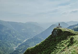
Boulder, CO
Nestled on the eastern aspect of the foothills of the Colorado Rockies, the city of Boulder (population ~100,000) is a unique and idyllic hub for outdoor recreation—including cycling. With its proximity to a network of canyons that weave through the hills to the west, and open, rolling gravel with views of the mountains (and Boulder’s iconic Flatirons) to the east, Boulder is a town that offers riders a wide variety of terrain to travel on two wheels.
Boulder was founded as an outpost for prospectors who flocked to the area in the mid 1800’s and many of the canyon roads featured in the following routes were forged to facilitate these early settlers’ quest for gold (in fact, a very popular destination for cyclists is to the town of “Gold Hill”).
And while the hunt for rare minerals was relatively short-lived, Boulder’s climate and landscapes (and Colorado’s broadly) continued to attract people drawn by the allure of an invigorating mountain lifestyle—not so different from today. Fortunately, in 1967 (as Colorado’s population continued to grow), Boulder residents had the foresight to vote into law a Greenbelt surrounding the city.
By approving a slight increase in sales tax, the city was able to acquire some 30,000+ acres to remain undeveloped, and thereby maintain an undeveloped perimeter around the city for recreation and wildlife habitat. This, in large part, is why there is access in most all directions to superior riding just minutes from downtown.
Trails to Moxie Bread Co.
 ALL-ROAD


Sometimes a coffee and a pastry offer the best excuse to get out for a spin. This route delivers that—at the Louisville bakery Moxie—but takes riders there via scenic gravel paths, two-track and single track with sweeping views of the foothills and Flatirons that make up Boulder’s western skyline.
The rockiness of the two-track is fairly short lived and the singletrack is quite smooth so any all-road or gravel bike should do the trick. Starting from downtown (routed here from a bike shop) connect a few of Boulder’s many bike paths to make your way south. At 11mi (17.5km), pick up the Community Ditch trail and follow trails for the next 11mi to Moxie in Louisville.
The bakery occupies a refurbished house, one of the oldest buildings in town, and specializes in farmhouse breads and rustic pastries made using locally-sourced, freshly milled flours (some made from heirloom wheat). From downtown Louisville, a few more paved bikeways will bring you to Teller Farms, a gravel connection that boasts some of the best views of the peaks along the Continental Divide. Following Teller, turn west and cruise back to downtown.
North Boulder Tour de Gravel
ALL-ROAD 


This route serves up some of Boulder County’s finest, flatter gravel terrain. Staged from the center of town, the route heads north towards Boulder Reservoir and the surface turns to dirt at just 5mi/ 8km in. Keep an eye out for eagles and hawks as you circle the reservoir and crest a few rollers—these birds of prey love to haunt the skies in this area.
Past the reservoir, the route continues to weave a line north, threading together low-traffic (though popular among other cyclists) bucolic county roads until its northern terminus in Hygiene. Hygiene is a small community (not much more than an intersection on the main street) but it is home to The Mountain Fountain, a small country store that caters to cyclists with a few cafe offerings and outdoor seating for hungry riders.
The highlight of the route comes along the return trip south. After a short climb up Gun Barrel Hill, the wide gravel path narrows to the engaging and punchy two-track that makes up the East Boulder Trails. This section only lasts a few miles but in this direction it offers a fun and dynamic intermission. Be sure to check your speed on the descents as some of the turns are sharp!
Two Quick Climbs
ALL-ROAD 


At just under 18mi/ 30km but with 2200ft/700m of climbing, this route packs a quick punch via two short climbs just minutes from town. The first climb travels pavement on the ascent and switches over to dirt for a fast descent while the second provides the reverse—a gravel climb to a paved descent down one of Boulder’s most iconic roads.
Staged from one of Boulder’s most reputable coffee shops, Boxcar Coffee, head west to access Sunshine Canyon. At 3mi/5km in, there is a short gravel cut thru that rejoins Sunshine Canyon but provides a little more time off tarmac (Timber Trail; mapped here)—take it if you want bonus dirt or continue on Sunshine. Turn off onto Poorman Rd (left) after just over 4mi/7km and 1000ft/300m climbed. This dirt connector weaves through stands of evergreens while offering a few views of the divide before the grade changes to a fast downhill. At the bottom of the hill, turn left of Fourmile Canyon Drive for a bit more descending. At the intersection with Boulder Canyon continue straight across onto the bike path and follow the path west until it ends at Chapman Drive.
One of Boulder’s backyard gems, Chapman is a gravel road closed to motor vehicles that climbs up the backside of Flagstaff Mountain. At 2.5mi/4km up, the climb winds through the forested hillside to gain just under 1000’/300m, with the steepest sections at the bottom. Once at the top, turn left for the winding descent down Flagstaff. While this is a popular road for cyclists, it is more popular among tourists so keep an eye out for vehicle traffic when sweeping through the many hairpin corners. The route finishes by rejoining the bike path and closes the loop again at Boxcar, which shares a space with the gourmet deli, Cured, that specializes in cheese, charcuterie, wine and sandwiches. Grab a sandwich on baguette (and maybe another espresso) and call it a day!
The Best Way to Nederland
ALL-ROAD 


Bring your climbing legs for this one as this ride takes an indirect and, at times, steep route to the small mountain town of Nederland (elevation: 8,236ft/ 2510m). The route starts with gradual and scenic climbing heading west along the Boulder Creek Path. As this gravel path follows its namesake creek past rocky outcroppings to join Fourmile Canyon, see if you can spot any climbers doing laps at the backyard crag. The warm up continues on the lower paved section of Fourmile Canyon until abruptly turning left onto Logan Mill Road (9mi). The next 3mi include sustained steep climbing to gain 1200ft/ 365m but the views and position in the network of surrounding canyons make it worthwhile. A short reprieve brings you down to join Sugarloaf Road, and from here it’s another 14mi/22km and 2400ft/730m of climbing to reach Nederland.
The climbing continues on Sugarloaf—with one welcome descent thrown into the mix—with the pavement eventually turning to dirt. Sugarloaf deposits you on the Peak to Peak HWY (which, should you want to skip the last section of dirt climbing, takes you directly to Nederland); turn left and follow it for just over a mile to pick up Caribou Road. Turning right on Caribou, a final gravel climb gives way to the landmark five-points junction. Take the option that points southwest to continue on Caribou and enjoy the victorious descent into Nederland. Nederland has a few cafes/ bakeries but the most popular choice among cyclists is undoubtedly Salto Coffee, with Crosscut Pizza vying for a close second.
For a low-traffic and scenic route back to Boulder, take Magnolia Road. From downtown Nederland, turn left onto Big Springs Drive and ride the short climb up to Peakview Drive before briefly connecting back into the Peak-To-Peak HWY to gain the junction with Magnolia Road. Turn left onto Magnolia and enjoy the rolling gravel and open views. Be wary that when Magnolia returns to pavement, the final 5mi down makes for quite the brake-dragging descent with several hairpin turns and grades approaching 15%. Stay alert for a couple miles on Boulder Canyon until you can rejoin the Boulder Creek Path for a few leisurely final miles back to town.
Triple Canyon Connector
ALL-ROAD 


Starting off with a sustained climb up to the old mining community of Gold Hill, this route spices things up on the return by incorporating a few fun trail connectors. From downtown Boulder, head up Fourmile Canyon. Once on Fourmile the road climbs for nearly 9mi/14km, gaining some nontrivial elevation along the way, eventually turning to dirt and winding through a few small mountain communities before opening up to sweeping views of Boulder below. At the top of the climb, the Gold Hill Store (just west on Main Street from the junction) offers packaged snacks, drinks, and simple fare in the form of sandwiches, pie, espresso and other treats.
Continue east and up a short climb on Sunshine Canyon Drive. After an initial snaking descent, don’t miss the quick left turn onto County Rd 83. Follow the road to its end and ride past a green gate on your left onto the Rowena Trail. The next 2mi offer mostly wooded, engaging singletrack with a couple rockier stretches that, depending on comfort level and tire size, should be mostly rideable on a gravel bike.
Rowena brings you to Lefthand Canyon, which after the singletrack provides a long smooth descent. Turn right up Olde Stage Road, then make an almost immediate left onto the Joder Ranch Trail. The Joder detour includes a short slaloming climb along an open hillside, a quick descent into the trees followed by a climb over the ridgeline before a final fast gravel buzz back down to the plains.
The final miles include more buff singletrack (stay alert for the cattleguards) and smooth gravel, before picking up bike paths back in town.

COINS CACHÉS. CAMBRIDGE
Explore roads less ridden along the flat, exposed Fenlands, over Belgian berg-like climbs and through the iconic backstreets of Cambridge.

COINS CACHÉS. SALZBURGERLAND
Whether you are looking for a steep satisfying climb or a gentle Sunday ride, the Bavarian Alps have so much to offer, both on and off road.
COINS CACHÉS. JULIJSKE ALPE
A hidden cycling paradise filled with high mountains, rolling hills, forest trails, and coastal rides. Stunning scenery best explored on two wheels.
COINS CACHÉS. PAYS DE GALLES
God's country explored on two wheels. Rides between two coasts, designed to explore routes and roads less ridden. Through the valleys and over the hills.
COINS CACHÉS. ARIÈGE
The Ariège rests on the border with Spain and Andorra and is a region rich in history which remains one of the most unspoilt areas of France.